Monday, December 17, 2012

Lima, Peru


Lima, Peru--December 17, 2012 in port 7AM-6PM

Lima


Our ship docked at theport of Callao (pronounced Kay-ya-oh), seven miles from central Lima and 10 miles from Miraflores.

I decided to take the Celebrityship’s (9:20AM) $12.50 round trip shuttle transfer to Miraflores hoping to catch a quick taxi from there to visit the historic UNESCO district in old town and a museum or two.

I discovered that traffic in Lima is atrocious!! It takes 45-60 minutes to go anywhere. Because of traffic congestion, it took us almost an hour to go 10 miles to Miraflores. I was told that navigating Lima is a complicated, time consuming task, made difficult by its sprawling character, heavy traffic, pollution, and chaotic network of confusing local transportation. Taxis are cheap but unregulated.

We arrived in Miraflores at 10:45AM. Miraflores is modern, with high-rises and American-esque shops along the waterfront. Although it is pretty, it does not look Peruvian. I found nothing of interest here. So I decided to join a couple I met on the shuttle (Sema and Milton from NJ), in negotiating with a taxi driver/tour guide, Mauro, to take us to visit colonial Lima.


We agreed to pay him $40 for a 2-hour tour. I paid $13 + 5 tip. We left at almost 11:00.

We were fortunate that he was personable, knowledgeable, patient, and spoke English well. He had lived in the US for a while.

Once again, we were surprised that traffic congestion made a short distance last for almost an hour to reach the city center. We passed the Plaza San Martin, Lima's grandest European-style square, en route.

Our first stop was a parking lot to relieve us of the vehicle. That enabled us to explore old town on foot. Our first stop was the gem of Central Lima: Convento y Museo de San Francisco, a baroque church with a serene courtyard, impressive neo-classical alter, 17th century library, breathtaking carved Moorish ceiling, and 1546-era catacombs. Nearby, was a great view of the Puenta de Piedra (stone bridge) with spectacular back drop of multicolored houses on mountainside villages across the river Rimac.


Next, we hastened to the Plaza de Armas (also known as the Plaza Mayor) to witness the noon changing of the guard ceremony. There was excitement in the air and throngs of tourists photographed the ceremony up close. I observed that the city's historic center has a generous share of Baroque, Renaissance, and Rococo-inspired buildings with elaborate facades, balconies, ornate gates and courtyards in the area around the Plaza Mayor.


The central bronze fountain survives from 1651, despite disastrous earthquakes that devastated the city. We looked from outside at the Cathedral and Archbishops Palace. Next time, I might go inside.

We strolled for a half an hour and even bargained for inexpensive souvenirs from street sellers. (They have neat items at great prices)

Lima has some of the most attractive wares as it is known for colorful markets that display a dazzling array of alpaca wool sweaters, blankets, ponchos, shawls, scarves, purses, hats and other woven items. Reproductions of Peru’s ancient civilizations’ ceramics are also abundant. The markets here are truly a feast for the eyes!


Mauro dropped us off at Miraflores at 1:10, making a stop along the way at an archeological site with llamas. Yes, we saw llamas in Lima!

I strolled around the waterfront mall then, took the 1:45 shuttle back to the port. There were at least 30 merchants selling gorgeous traditional Peruvian items at reasonable prices.

Next time, I will visit some of Peru’s famous museums.

Note: There are 2 port drop offs. One has a nice Indian market; the other is 5 minutes away in “no man’s land”. If they take you to the “dead port”, go to the other port for taxis to old town and for shopping.

Manta, Ecuador--Real Home of the "Panama Hat"


Manta Ecuador 2012


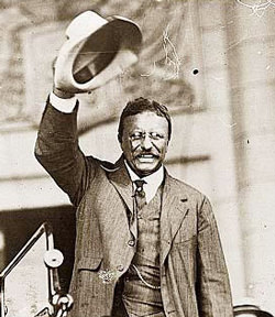
Today, (December 14, 2012), I visited Ecuador for the first time, in Manta, a picturesque fishing town, and 2nd largest port in the country. Manta is known for its booming tuna fishing, lively beaches, and colorful arts and handicrafts markets. Most notably is its proximity to the town of Monticristi, the epicenter of (erroneously named) “Panama Hat” manufacturing. Yes, the off-white, hand-woven hats with the black ribbon around the brim hail from Ecuador---not Panama. This misnomer resulted from a famous and widely circulated photograph of President Theodore Roosevelt, posing in a steam shovel in Panama (during the canal construction), sporting a Monticristi hat. The photo carried such significance because it is the first time a sitting US President travelled outside the US. He set a fashion trend and the hat gained recognition as a Panama, rather than Ecuador creation.
Hat Making Craft


I took the ship’s shuttle bus (10 min/$5.50) to the town center to visit the local handicraft market. I was overwhelmed by the abundant and bright colors, textures, and shapes, on display with such a wide diversity of goods from alpaca wool clothing and blankets, to pre-Columbian artifact replicas, to dazzling silver jewelry, to Tagua carvings, and of course, to the famous, hand-woven Monticristi hats.


Bargains are terrific here and I found the people to be sweet and gentle.


After strolling the market, I took a seat at a busy cafĂ© and decided to savor traditional Ecuadorian ceviche pescado (with plantain chips). It was delectable and cost only $2.75. (Ecuador’s currency is the $US). I stayed a while absorbing the sights, sounds, and smells while a lively Ecuadorian musical trio serenaded us.


It was a really pleasant day.


Panama Canal Transit

A Man, a Plan, a Canal: Panama (Famous Palindrome)


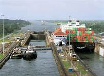
Today, we took the 50-mile journey from the Atlantic Ocean to the Pacific Ocean via the famous engineering marvel, The Panama Canal. Of note, the canal saves 8,000 off the route around Cape Horn.

I was fortunate to have taken a land tour of Colon, The largest set of locks (Gatun), and the colonial city of Panama City, yesterday. At Gatun, I witnessed two ships being carried through the locks, in two separate directions.

My Videos from Gatun Locks Viewing Area:

http://youtu.be/P1okiJyhOXs

http://youtu.be/4dvFFPIMmOc


We entered the canal at 7AM, reaching the 1st and largest set of locks, The Gatun Locks, at 7:30. We experienced the 3-step raising of the ship as we were pulled along by 3 sets of locomotives on each side. The 1st locks took 1.5 hours to transit; the 2nd and 3rd took approximately 45 minutes each.

I spent all day watching our progress, photographing sites along the way, from a lounge chair on deck and from various viewing points on the ship. It was exhilarating to be a part of a select group of 2000 tourists making this journey together.


My video of transit from ship: http://youtu.be/fRhNphGp9QE


The Transit

Here is a brief summary of how the locks work:

The canal is composed of 3 sets of locks that operate as water lifts to elevate ships 3 feet above sea level to the level of the Gatun Lake, in their transit of the continental Divide, then, lower them back down to sea level on the opposite side of the isthmus.


The History

I read books, listened to lectures, and watched the documentary film: A Man, A Plan, and A Canal: Panama and still cannot get enough of the history!


In a nutshell—the history is a fascinating account of how the vision and determination of a few strong personalities, triumph over adversity, and simple synchronicity helped to produce one of the greatest engineering marvels of all time. From the confident wheeling dealing financier De Lessups, mastermind of the Suez Canal; to the ingenious, persuasive, persistent Bunau-Varilla; to the expansionist, outspoken, champion of military sea power, Theodore Roosevelt; to the 3 chief engineers charged with project completion, there were a colorful cast of characters involved---none of whom, were Panamanian nor Columbian.


Despite the numerous obstacles during 2 separate decades of a French then American campaign such as impenetrable mountainous terrain; monsoon rains that produced damaging landslides; swarms of deadly disease-carrying mosquitoes (yellow fever and malaria killed thousands) and poisonous snakes; inadequate equipment; lack of infrastructure; dwindling and insufficient funding; stubborn personalities; the wild, unruly Chagres river; stifling heat; and more----- the engineering feat was finally completed!

There were major twists of fate including 1) close votes in congress that determined a locks vs. sea-level canal (vote of 36 to 31); 2) Congress voting 42 to 34 to locate the canal in Panama versus Nicaragua, and 3) President Mc Kinley’s assassination that placed Theodore Roosevelt, the persistent expansionist, at the helm of the country.


What’s most interesting is that the only reason the country of Panama came into being is because of the drive to build a canal linking Atlantic to the Pacific. Columbia, of which Panama was a district, erected several “obstacles” to the canal construction----chiefly, a refusal to turn over sovereignty to the US. In response, The US and Bunau-Varilla instigated a revolution, helping Panama gain its independence from Columbia. The orchestration of this bloodless coup did not originate with Panamanians but with a Frenchman and the US, through the use of “gunboat diplomacy”.


If you plan to transit the canal, I highly recommend studying its colorful history, in advance!